|
|
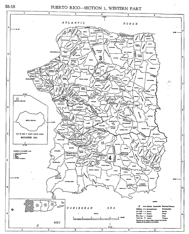
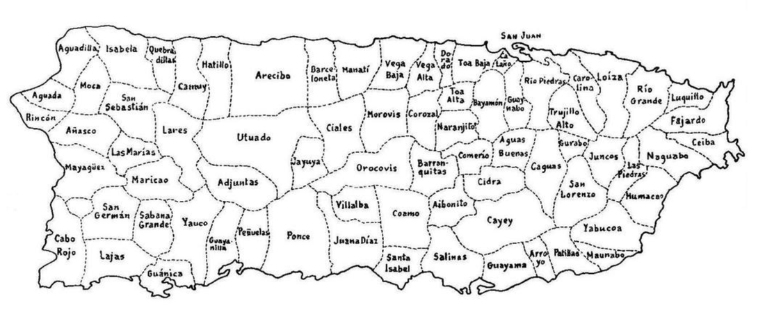
Los Pueblos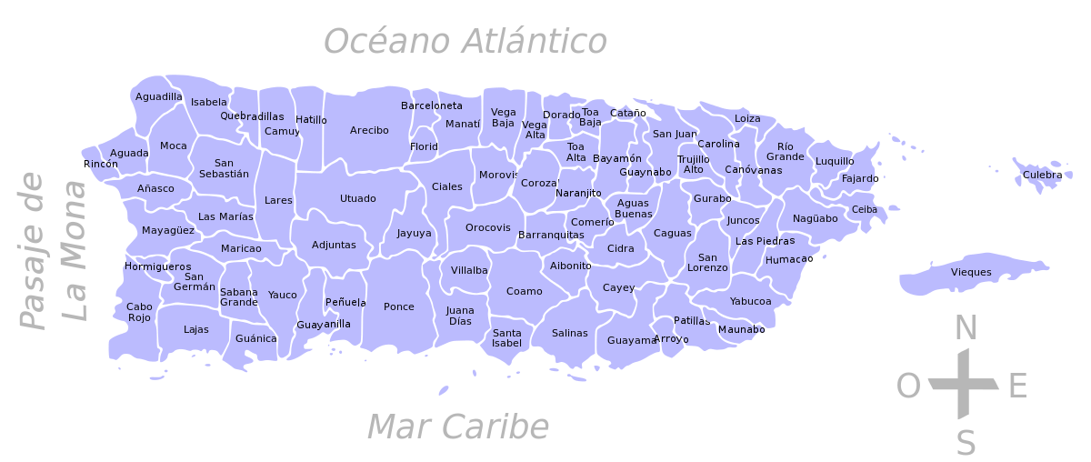
Click map to enlarge
|
Breakdown of Puerto Rico Geography
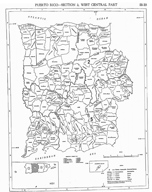
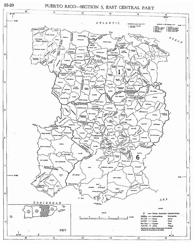
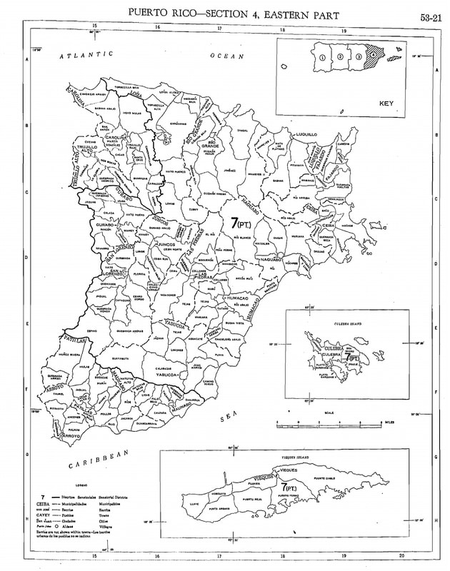
Puerto Rico is divided into 78 municipalities, which many states would refer to as counties. Within these municipalities, there are 'barrios' or districts. which are official, legal, geographical boundaries. These barrios are official, legal, geographical boundaries, unlike in the states where a barrio may refer to a neighborhood, such as Fairhill in Philadelphia or East Harlem in Manhattan.
Each barrio is further divided into sectors, akin to neighborhoods in the United States, although in Puerto Rico's countryside, due to the vastness of rural areas, these sectors often resemble villages more than neighborhoods. The heart of each town lies within its "pueblo," where you'll typically find the central plaza and Catholic church. These areas are commonly known as "... Pueblo."
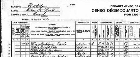
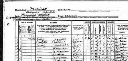
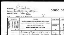
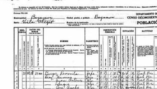
In larger cities like San Juan, Ponce, Mayagüez, and Caguas, the divisions can become more complex due to the presence of additional subsets such as urbanizations. When reading census records from 1910 to 1940, you won't typically find street names in rural areas. Instead, the form will indicate the municipality and barrio at the top left-hand corner.
I've included the "foundation" dates of each pueblo to provide context for when European settlers officially established these towns. This signifies that there were enough settlers and a church for the Spanish monarch to grant official status to a municipality. However, it's important to acknowledge that these areas were likely inhabited by the native Taínos long before Europeans and Africans arrived. Unfortunately, there is limited information available about specific places from this period in history. It's safe to assume that if you don't have ancestors directly from Europe, the matrilineal line of your ancestors likely includes indigenous heritage.
When searching on Ancestry.com, you'll find the municipality listed as "county" and the barrio as "township."
*Be sure not to have your browser on translate mode on this page or the place names won't be accurate.*
Each barrio is further divided into sectors, akin to neighborhoods in the United States, although in Puerto Rico's countryside, due to the vastness of rural areas, these sectors often resemble villages more than neighborhoods. The heart of each town lies within its "pueblo," where you'll typically find the central plaza and Catholic church. These areas are commonly known as "... Pueblo."
In larger cities like San Juan, Ponce, Mayagüez, and Caguas, the divisions can become more complex due to the presence of additional subsets such as urbanizations. When reading census records from 1910 to 1940, you won't typically find street names in rural areas. Instead, the form will indicate the municipality and barrio at the top left-hand corner.
I've included the "foundation" dates of each pueblo to provide context for when European settlers officially established these towns. This signifies that there were enough settlers and a church for the Spanish monarch to grant official status to a municipality. However, it's important to acknowledge that these areas were likely inhabited by the native Taínos long before Europeans and Africans arrived. Unfortunately, there is limited information available about specific places from this period in history. It's safe to assume that if you don't have ancestors directly from Europe, the matrilineal line of your ancestors likely includes indigenous heritage.
When searching on Ancestry.com, you'll find the municipality listed as "county" and the barrio as "township."
*Be sure not to have your browser on translate mode on this page or the place names won't be accurate.*
Over the centuries, some places changed names, became absorbed into other municipalities or separated from larger ones. For each area of the island I listed places that had a name change after 1825, which may affect your research. For example, if you are looking for a census record for Cataño before 1930, you must search in Bayamón as Cataño didn't become its own municipality until 1927. In the table below, I will put an asterisk next to those municipalities that either changed its name or was a part of another.
At the very bottom of this page I included a detailed list of the dates of establishment but also from which municipality each originated in. This is important to know when looking at church records from before 1885. If you are looking for records for Maricao from before 1874, you must look in records of San German because Maricao was still a part of San German until 1874. Barceloneta was part of Manatí until 1881. Carolina was a barrio of San Juan called Trujillo Bajo until 1854. The list will be very helpful so definitely check it out!
Also keep in mind that in the early 20th century, particularly in rural areas (el campo), people didn't leave very often. Therefore, they may have referred to their barrio as their place of residence, passing that name down over the generations without using the name of the larger municipality the barrio belonged to. For example, my great-grandparents lived in Barrio Rincón in Cidra. If I only had the name Rincón passed down, I may have misidentified this as the municipality Rincón and spend time looking on the wrong side of the island. Conversely, it is good to know the barrio as each municipality is quite large so knowing Cidra only isn't as helpful as knowing the barrio. Because rural areas didn't (and some still don't) have street names and formal address numbers, knowing the barrio will help in finding ancestors each decade.
This can become frustrating when looking for specific people and coming up empty. Be sure to check the list below to find place names that are the same but in different areas. This will help expand your search. Another example: Puerto Rico has several places with the name Ceiba. The municipality Ceiba in the eastern part of the island but there are also barrios named Ceiba in Florida, Vega Baja, Cidra, Las Piedras, Juncos and Aguadilla! So if you think you've hit a dead end, remember that there may be other places to look.
*Municipalities are listed from west to east and north to south*
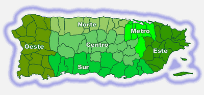
Northern Puerto Rico |
|
Municipalidad |
Barrios |
Camuy 1807 |
Abra Honda, Camuy Arriba, Cibao, Ciénagas, Membrillo, Piedra Gorda, Pueblo, Puente, Puertos, Quebrada, Santiago, Yeguada, Zanja |
Hatillo 1823 |
Aibonito, Bayaney, Buena Vista, Campo Alegre, Capáez, Carrizales, Corcovado, Hatillo Pueblo, Naranjito, Pajuil |
Arecibo 1515 |
Arecibo Pueblo, Arenalejos, Arrozal, Cambalache, Carreras, Domingo Ruiz, Dominguito, Esperanza, Factor, Garrochales, Hato Abajo, Hato Arriba, Hato Viejo, Islote, Miraflores, Río Arriba, Sabana Hoyos, Santana, Tanamá |
Barceloneta 1881 separated from Manatí |
Barceloneta Pueblo, Garrochales, Florida Afuera, Palmas Altas |
Florida 1971 separated from Barceloneta |
Florida Pueblo y Florida Adentro - sectores: Aguacate, La Ceiba, Comisión, Fogones, Los Guanos, Pajonal, Parcelas Arroyo, Parcelas Selgas, El Perol, Pueblo Viejo, San Agustín, La Vázquez, La Villamil, La Dorta, Tosas |
Manatí 1738 |
Barrio Altagracia, Bajura Afuera, Bajura Adentro, Coto Norte, Coto Sur, Manatí Pueblo, Río Arriba Poniente, Río Arriba Saliente, Tierras, Nuevas Poniente, Tierras Nuevas Saliente |
Vega Baja 1776 |
Algarrobo, Almirante Norte, Almirante Sur, Cabo Caribe, Ceiba, Cibuco, Puerto Nuevo, Pugnado Adentro, Pugnado Afuera, Quebrada Arenas, Río Abajo, Río Arriba, Vega Baja Pueblo, Yeguada |
Vega Alta 1775 |
Bajura, Candelaria, Cienegueta, Espinosa, Maricao, Mavilla, Sabana, Barrio Pueblo |
Dorado 1842 |
Dorado Pueblo, Higuillar, Maguayo, Río Lajas, Mameyal, Espinosa, Santa Rosa, Los Puertos |
Toa Baja 1745 |
Candelaria, Media Luna, Palo Seco, Sábana Seca, Toa Baja Pueblo, Ingenio, Campanilla |
Toa Alta 1751 |
Pueblo, Contorno, Galateo, Mucarabones, Ortiz, Piñas, Quebrada Arenas, Quebrada Cruz, Río Lajas |
Central Puerto Rico |
|
Municipalidad |
Barrios |
Lares 1827 |
Bartolo, Buenos Aires, Callejones, Castañer, Espino, Lares, Lares Pueblo, La Torre, Mirasol, Pezuela, Piletas, Pueblo, Río Prieto |
Utuado 1739 |
Ángeles, Arenas, Caguana, Caníaco, Caonillas Abajo, Caonillas Arriba, Consejo, Don Alonso, Guaonico, Las Palmas, Limón, Mameyes Abajo, Paso Palma, Río Abajo, Santa Rosa, Roncador, Sabana Grande, Salto Abajo, Salto Arriba, Santa Isabel, Tetuán 1, Tetuán 2, Utuado Pueblo, Viví Abajo, Viví Arriba |
Adjuntas 1815 |
Adjuntas Pueblo, Capáez, Garzas, Guayabo Dulce, Guayo, Guilarte, Juan González, Limaní, Pellejas, Portillo, Portugués, Saltillo, Tanamá, Vegas Abajo, Vegas Arriba, Yahuecas, Yayales |
Jayuya 1911 separated from Utuado |
Jayuya Pueblo, Jayuya Abajo, Coabey, Collores, Jauca, Mameyes Arriba, Pica, Río Grande, Saliente, Veguitas, Zamas |
Ciales 1820 |
Jaguas, Pesas, Cordillera, Pozas, Hato Viejo, Ciales Pubelo, Cialitos, Toro Negro, Frontón |
Morovis 1818 |
Barahona, Cuchillas, Franquez, Montellano, Morovis Pueblo, Morovis Norte, Morovis Sur, Pasto, Perchas, Río Grande, San Lorenzo, Torrecillas, Unibón, Vaga |
Orocovis 1825 formerly known as Barros |
Ala de la Piedra, Barros, Bauta Abajo, Bauta Arriba, Bermejas, Botijas, Cacaos, Collores, Damián Abajo, Damián Arriba, Gato, Mata de Cañas, Pellejas, Sabana, Saltos, Orocovis |
Villalba 1917 separated from Juana Díaz |
Caonillas Abajo, Caonillas Arriba, Hato Puerco Abajo, Hato Puerco Arriba, Vacas, Villalba Abajo, Villalba Arriba, Villalba Pueblo |
Corozal 1795 |
Abras, Barrio Pueblo, Cibuco, Cuchillas, Dos Bocas, Magueyes, Maná, Negros, Padilla, Palmarejo, Palmarito, Palos Blancos |
Naranjito 1824 |
Achiote, Anones, Cedro Abajo, Cedro Arriba, Guadiana, Lomas, La Colina, Nuevo, Naranjito Pueblo |
Barranquitas 1803 |
Barrancas, Barranquitas Pueblo, Cañabón, Helechal, Honduras, Palo Hincado, Quebrada Grande, Quebradillas |
Comerío 1826 formerly known as Sabana del Palmar |
Comerío, Pueblo, Cedrito "La Prieta", Naranjo, Palomas, Doña Elena, Río Hondo, Piñas, Vega Redonda, Cejas |
Aibonito 1824 |
Aibonito Pueblo, Algarrobo, Asomante, Caonillas, Cuyón, Llanos, Pasto, La Plata, Robles |
Aguas Buenas 1798/1838 from Caguas |
Aguas Buenas, Bairoa, Bayamoncito, Cagüitas, Jagüeyes, Juan Asencio, Mula, Mulitas, Sonadora, Sumidero |
Cidra 1809 separated from Cayey |
Arenas, Bayamón, Beatriz, Ceiba, Certenejas, Cidra Pueblo, Honduras, Montellano, Rabanal, Rincón, Río Abajo, Salto, Sud, Toíta |
Cayey 1773 |
Pueblo, Beatriz, Cedro, Cercadillo, Culebras Alto, Culebras Bajo, Farallón, Guavate, Jájome Alto, Jájome Bajo, Lapa, Matón Abajo, Matón Arriba, Montellano, Pasto Viejo, Pedro Ávila, Piedras, Quebrada Arriba, Rincón, Sumido, Toíta, Vegas |

Eastern Puerto Rico |
|
Municipalidad |
Barrios |
Loíza 1719 |
Loíza Pueblo, Medianía Alta, Medianía Baja, Torrecilla Baja |
Canóvanas 1970 separated from Loíza |
Canóvanas, Canóvanas Pueblo, Cubuy, Hato Puerco (Campo Rico), Lomas, Torrecilla Alta (La Central) |
Rio Grande 1840 separated from Loíza |
Carola, Ciénaga Alta, Ciénaga Baja, El Verde, Guzmán Abajo, Guzmán Arriba, Herreras, Jiménez, La Ponderosa, Las Dolores, Las Tres T, Malpica, Mameyes, Palmer, Río Grande Pueblo, Zarzal |
Luquillo 1797 |
Juan Martín, Luquillo Pueblo, Mameyes I, Mata de Plátano, Pitahaya, Sabana |
Fajardo 1772 |
Barriada Obrera, Las Cabezas (Las Croabas), Demajagua, Fajardo Pueblo, Fajardo Gardens, Florencio, Monte Brisas, Monte Mar, Monte Vista, Naranjo, Paraiso, Quebrada Fajardo, Quebrada Vueltas, Río Arriba, Santa Isidra, Sardinera, Jerusalén, Valle Puerto Real, Veve Calzada, Villa Clarita |
Ceiba 1838 annexed by Fajardo in 1898, separated in 1914 |
Ceiba Pueblo, Chupacallos, Daguao, Guayacán, Machos, Quebrada Seca, Río Abajo, Saco |
Naguabo 1794 |
Daguao, El Duque, Húcares, Santiago y Lima, Maizales, Mariana, Peña Pobre, Florida, Río Blanco, Pueblo, Rio (Brazo Seco) |
Humacao 1793 |
Pueblo, Mambiche, Antón Ruiz, Punta Santiago, Collores, Mabú, Tejas, Río Abajo, Cataño, Mariana, Buena Vista, Candelero Arriba, Candelero Abajo |
Las Piedras 1801 |
Boquerón, Ceiba, Collores, El Río, Pueblo, Montones, Quebradas Arenas, Tejas |
Juncos 1782 separated f. Humacao |
Caimito, Ceiba Norte, Ceiba Sur, Gurabo Abajo, Gurabo Arriba, Lirios, Mamey, Valenciano Abajo, Valenciano Arriba |
Gurabo 1815 |
Celada, Hato Nuevo, Jagual, Jaguas, Mamey, Masas, Navarro, Rincón, Santa Rita |
San Lorenzo 1811 |
Cerro Gordo, Espino, Florida, Hato, Jagual, Quebrada, Quebrada Arenas, Quebrada Honda, Quemados, Cayaguas |
Yabucoa 1793 |
Jácanas, Juan Martín, Calabazas, Limones, Camino Nuevo, Guayabota, Playa Guayanés, Aguacate, Tejas, Yabucoa Pueblo |
Maunabo 1799 |
Calzada, Emajagua, Lizas, Matuyas Alto, Matuyas Bajo, Palo Seco, Tumbao, Quebrada Arenas, Talante |
Culebra 1881 |
Pueblo, Flamenco, Fraile, Playa Sardinas I, Playa Sardines II, San Isidro |
Vieques 1843 |
Isabel Segunda, Florida, Puerto Diablo, Puerto Ferro, Puerto Real, (Llave, Mosquito, Punto Arenas - occupied by US military from 1941-2003) |
Western Puerto Rico |
|
Municipalidad |
Barrios |
Aguadilla 1775 |
Aguadilla Pueblo, Aguacate, Arenales, Boriquén, Caimital Alto, Caimital Bajo, Camaceyes, Ceiba Alta, Ceiba Baja, Corrales, Guerrero, Maleza Alta, Maleza Baja, Montaña, Palmar, Victoria |
Isabela 1819 |
Arenales Altos, Arenales Bajos, Bajura, Bejucos, Coto, Galateo Alto, Galateo Bajo, Guayabos, Guerrero, Jobos, Llanadas, Mora, Planas, Isabela Pueblo |
Quebradillas 1823 |
Cacao, Charcas, Cocos, Guajataca, Quebradillas, Pueblo, San Antonio, San José, Terranova |
Rincón 1771 |
Atalaya, Barrero, Calvach, Cruces, Ensenada, Jagüey, Pueblo, Puntas, Rincón Pueblo, Río Grande |
Aguada 1510 |
Aguada Pueblo, Asomante, Atalaya, Carrizal, Cerro Gordo, Cruces, Espinar, Guanábano, Guaniquilla, Guayabo, Jagüey, Laguna, Mal Paso, Mamey, Marías, Naranjo, Piedras Blancas, Río Grande |
Moca 1772 |
Aceitunas, Capá, Centro, Cerro Gordo, Cruz, Cuchillas, Marías, Naranjo, Plata, Pueblo (zona rural y urbana), Rocha, Voladoras |
San Sebastian 1752 |
Aibonito, Alto Sano, Bahomamey, Calabazas, Cibao, Cidral, Culebrinas, Eneas, Guacio, Guajataca, Guatemala, Hato Arriba, Hoya Mala, Juncal, Magos, Mirabales, Perchas Uno, Perchas Dos, Piedras Blancas, Pozas, Robles, Saltos, San Sebastián Pueblo, Sonador |
Añasco 1733 |
Añasco Pueblo, Añasco Abajo, Añasco Arriba, Caguabo, Caracol, Carreras, Casey Abajo, Casey Arriba, Cerro Gordo, Cidra, Corcovada, Dagüey, Espino, Hatillo, Humatas, Marías, Miraflores, Ovejas, Piñales, Playa, Quebrada Larga, Río Arriba, Río Cañas |
Las Marías 1871 separated from Mayagüez |
Alto Sano, Anones, Bucarabones, Buena Vista, Cerrote, Chamorro, Espino, Furnias, Las Marías Pueblo, Maravilla Este, Maravilla Norte, Maravilla Sur, Naranjales, Palma Escrita, Purísima Concepción, Río Cañas |
Mayagüez 1772 |
Algarrobo, Bateyes, Guanajibo, Isla de Mona e Islote Monito, Juan Alonso, Leguízamo, Limón, Malezas, Mayagüez Arriba, Mayagüez Pueblo, Miradero, Montoso, Naranjales, Quebrada Grande, Quemado, Río Cañas Abajo, Río Cañas Arriba, Río Hondo, Rosario, Sábalos, Sabanetas |
Maricao 1874 separated from San German |
Bucarabones, Indiera Alta, Indiera Baja, Indiera Fría, Maricao Afuera, Maricao Pueblo, Montoso |
Hormigueros 1874 separated from San German |
Hormigueros Pueblo, La Prerra, Jaguitas, Valle Hermoso, Guanajibo, Lavadero, Verdum, Planbonito, Carretera Nueva, San Romualdo, Hoya Grande, El Hoyo, Las Plumas |
San Germán 1573 |
Ancones, Caín Alto, Caín Bajo, Cotuí, Duey Alto, Duey Bajo, Guamá, Hoconuco Alto, Hoconuco Bajo, Maresúa, Minillas, Retiro, Rosario Alto, Rosario Bajo, Rosario Peñón, Sabana Eneas, Sabana Grande Abajo, San Germán Pueblo, Tuna |
Sabana Grande 1813 |
Maginas, Machuchal, Rayo, Rincón, Santana, Susúa, Tabonuco, Torre, Pueblo |
Cabo Rojo 1771 |
Bajura, Boquerón, Guanajibo, Llanos Costa, Llanos Tuna, Miradero, Monte Grande, Pedernales |
Lajas 1883 separated from San German |
Candelaria, La Costa, Lajas Arriba, Lajas Pueblo, Llanos, Palmarejo, Parguera, Paris, La Plata, Sábana Yeguas, Santa Rosa |
Guánica 1914 separated from Yauco |
Arenas, Bélgica, Caño, Carenero, Ciénaga, Ensenada, Fuig, Guánica Pueblo, Guaypao, Magueyes, Montalva, Playa Santa, Susúa Baja, La Joya |

Southern Puerto Rico |
|
Municipalidad |
Barrios |
Yauco 1756 |
Aguas Blancas, Algarrobo, Almácigo Alto, Almácigo Bajo, Barinas, Caimito, Collores, Diego Hernandez, Duey, Frailes, Jácana, Naranjo, Palomas, Quebradas, Ranchera, Río Prieto, Rubias, Sierra Alta, Susúa Alta, Susúa Baja, Vegas, Yauco Pueblo |
Guayanilla 1833 |
Barrero, Boca, Cedro, Consejo, Guayanilla Pueblo, Indios, Jagua Pasto, Jaguas, Llano, Macaná, Magas, Pasto, Playa, Quebrada Honda, Quebradas, Rufina, Sierra Baja |
Peñuelas 1793 |
Barrea, Coto, Cuevas, Encarnación, Jaguas, Macaná, Penuelas Pueblo, Quebrada Ceiba, Rucio, Santo Domingo, Tallaboa Alta, Tallaboa Poniente, Tallaboa Saliente, Caracoles 1, Caracoles 2, Caracoles 3, Belleza, Alturas 1, Alturas 2, Las Quebradas |
Ponce 1692 |
Canas, Magueyes, Portugues, Machuelo Arriba, Sabanetas, Coto Laurel, Cerrillos, Anón, Canas, Capitanejo, Coto Laurel, Guaraguao, Marueño, Quebrada Limón, Real, San Patricio, Bucana, Canas Urbano, Machuelo Abajo, Magueyes Urbano, Playa, Portugués Urbano, San Antón, Primero, Segundo, Tercero, Cuarto, Quinto, Sexto, Magueyes, Tibes, Montes Llanos, Maragüez, Portugués, Machuelo Arriba, Cerrillos, Sabanetas |
Juana Díaz 1798 |
Amuelas, Cayabo, Capitanejo, Cintrona, Collores, Emajagual, Guayabal, Jacaguas, Juana Díaz Pueblo, Lomas, Río Cañas Abajo, Río Cañas Arriba, Sabana Llana, Tijeras |
Coamo 1579 |
Coamo Arriba, Cuyón, Hayales, Los Llanos, Palmarejo, Pasto, Pedro García, Coamo Pueblo, Pulgillas, San Idelfonso, Santa Catalina |
Santa Isabel 1842 separated from Coamo (formerly known as Coamo Abajo) |
Santa Isabel, Peñuelas, Playa, Boca Velázquez, Descalabrado, Jauca I, Jauca II, Felicia I, Felicia II |
Salinas 1841 separated from Coamo |
Aguirre, Lapa, El Coco, Sabana Llana, La Plena, Las 80s, La Playa, La Playita, Las Mareas, Palmas, Quebrada Yeguas, Río Jueyes, Pueblo, Vertero, El Coqui |
Guayama 1736 |
Algarrobo, Caimito, Carite, Carmen, Guamaní, Jobos, Machete, Palmas y Pozo Hondo, Pueblo |
Arroyo 1855 separated from Guayama |
Arroyo Pueblo, Ancones, Guásimas, Palmas, Pitahaya, Yaurel |
Patillas 1811 |
Apeadero, Bajo, Cacao Alto, Cacao Bajo, Egozcue, Guardarraya, Jacaboa, Jagual, Mamey, Marín, Mulas, Muñoz Rivera (El Real), Pollos, Pueblo, Quebrada Arriba, Ríos |

Metropolitan Area |
|
Municipalidad |
Barrios |
Cataño 1927 separated from Bayamón |
Bahía, Bay View, Cucharillas, Dos Ríos, Enramada, Jardines de Cataño, Juana Matos, Las Vegas, Mansión del Norte, Mansión del RíoMansión del Sur, Marina Bahía, Matienzo Cintrón, Puente Blanco, Sector Cucharillas, Urb. Las Palmas, Valparaíso, Vista del Morro, William Fuertes |
Bayamón 1772 |
Buena Vista, Cerro Gordo, Dajaos, Guaraguao Abajo, Guaraguao Arriba, Hato Tejas, Juan Sánchez, Minillas, Nuevo, Pájaros, Santa Olaya |
Guaynabo 1769 |
Guaynabo Pueblo, Camarones, Frailes, Guaraguao, Hato Nuevo, Mamey, Pueblo Viejo, Río, Santa Rosa, Sonadora |
San Juan 1509 |
Caimito, Cupey, El Cinco, Gobernador Piñero, Hato Rey Central, Hato Rey Norte, Hato Rey Sur, Monacillo, Monacillo Urbana, Oriente, Pueblo, Quebrada Arenas, Sabana Llana Norte, Sabana Llana Sur, San Juan Antiguo (Viejo San Juan), Santurce, Tortugo, Universidad |
Trujillo Alto 1801 |
Carraízo, Las Cuevas, Dos Bocas, La Gloria, antes llamada (Quebrada Infierno), Quebrada Grande, Quebrada Negrito, San Justo, Barrio Pueblo |
Caguas 1775 |
Caguas Pueblo, Bairoa, Beatriz, Borinquen, Cañabón, Cañaboncito, Rio Cañas, San Antonio, San Salvador, Tomás de Castro, Turabo |
Carolina 1857 separated from Loíza, formerly Trujillo Bajo |
Barrazas, Cacao, Cangrejo Arriba, Canovanillas, Carolina Pueblo, Carruzos, Hoyo Mulas, Cedro, Martín González, Sabana Abajo, San Antón, Santa Cruz, Trujillo Bajo (sector: Isla Verde, Camp Rico) |

San Juan
|
San Juan annexed areas that are still referred to by their original names which can be confusing. Such as El Roble became Río Piedras which was eventually annexed by San Juan in 1951. San Mateo de Cangrejos became Santurce in 1880 and was also annexed by San Juan. Santurce has many sectores (neighborhoods) that are well-known in their own right such as Ocean Park, Miramar, and Condado.
Before San Juan absorbed the other municipalities around it, the areas known as sectores now were its barrios in 1910, 1920, and 1930 censuses. These areas are: Ballaja, Mercado, Catedral, Marina, San Francisco, San Cristobal, Puerta de Tierra and Isla de Cabra which was a leper colony from 1883-1926. |
For those of you able to trace far enough back, it is important to know the timelines of the municipios. WIthout understanding how the names of the places have changed around a particular area, one may erroneously believe one's family has moved around when they in fact have always been in the same place.
1510 - Aguada was established
1515 - Arecibo was established
1521 - San Juan was established (originally Puerto Rico)
1573 - San German was established
1579 - Coamo was established
1510 - Aguada was established
1515 - Arecibo was established
1521 - San Juan was established (originally Puerto Rico)
1573 - San German was established
1579 - Coamo was established
|
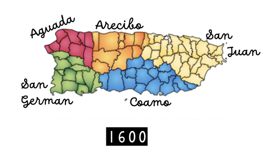
From the time that the the first Europeans arrived, it took almost one hundred years for each of the five original municipalities to be established. From those five, each pueblo or municipality seceded over the next few centuries. The indents indicate from which municipality the pueblo once belonged. The years listed are when the pueblos were officially recognized by the monarchy of Spain. Each pueblo was populated long before it was made official by indigenous Tainos and/or later by immigrants and former slaves.
1510 - Aguada established 1725 - San Antonio de La Tuna 1807 - Camuy 1819 - Isabela 1823 - Quebradillas 1752 - San Sebastián 1831 Lares 1771 - Rincón 1772 - Moca 1775 - Aguadilla 1515 - Arecibo established 1738 Manatí 1818 Morovis 1820 Ciales 1881 Barceloneta 1971 Florida 1739 Utuado 1911 Jayuya 1775 Vega Alta 1776 Vega Baja 1815 Adjuntas 1823 Hatillo 1573 - San German established 1733 Añasco 1756 Yauco 1833 Guayanilla 1914 Guánica 1771 Cabo Rojo 1772 Mayagüez 1871 Las Marias 1813 Sabana Grande 1874 Hormigueros 1874 Maricao 1883 Lajas 1854 - Vieques annexed
1917 - Culebra established part of Puerto Rico |
1521 - San Juan was established 1626 Caguas established as cattleland 1714 Rio Piedras 1719 Loiza 1801 Trujillo Alto 1840 Rio Grande 1970 Canóvanas 1722 Humacao (originally Buena Vista) 1793 Yabucoa 1794 Naguabo 1797 Luquillo 1772 Fajardo 1838 Ceiba 1801 Las Piedras 1745 Toa Baja 1751 Toa Alta 1795 Corozal 1842 Dorado 1769 Guaynabo 1772 Bayamón 1826 Comerío (originally Sabana del Palmar) 1824 Naranjito* 1927 Cataño 1775 Caguas 1801 Las Piedras 1782 Juncos 1811 San Lorenzo 1798 kinda Aguas Buenas 1815 Gurabo 1838 Aguas Buenas 1857 Carolina (originally Trujillo Bajo) 1579 - Coamo established 1692 Ponce 1798 Juana Díaz 1917 Villalba 1793 Peñuelas 1736 Guayama 1799 Maunabo 1811 Patillas 1855 Arroyo 1773 Cayey 1803 Cidra 1803 Barranquitas 1825 Orocovis 1824 Aibonto 1841 Salinas 1842 Santa Isabel |
Crests of the PueblosIn front of the capitol building in San Juan, there is a small plaza that sits on the coast of the Atlantic Ocean which has a statue of San Juan Bautista. On either side of the statue is a beautiful display of glass mosaics of the crest of each of the municipalities. I took pictures of many of them.
|
|
"Perdonadle al desterrado
ese dulce frenesí:
vuelvo a mi mundo adorado,
y yo estoy enamorado
de la tierra en que nací."
- José Gautier Benítez
References:
Pueblos de Nuestro Puerto Rico, 2nd ed. ©1999, Publicaciones Puertorriqueñas
Pueblos de Nuestro Puerto Rico, 2nd ed. ©1999, Publicaciones Puertorriqueñas